


col du loup à partir du Biolley

franquen
User
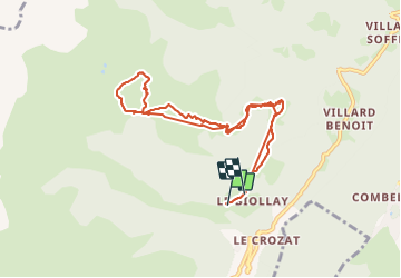

Length
9.2 km

Max alt
2009 m

Uphill gradient
830 m
Km-Effort
20 km

Min alt
1330 m

Downhill gradient
808 m
Boucle
No
Creation date :
2024-01-21 08:14:47.094
Updated on :
2024-01-21 13:32:23.358
5h14
Difficulty : Very easy

FREE GPS app for hiking
 SityTrail
IGN / Geographical institutes
SityTrail Plus
The world is yours!
About
Trail Touring skiing of 9.2 km to be discovered at Auvergne-Rhône-Alpes, Savoy, La Léchère. This trail is proposed by franquen.
Positioning
Country:
France
Region :
Auvergne-Rhône-Alpes
Department/Province :
Savoy
Municipality :
La Léchère
Location:
Bonneval
Start:(Dec)
Start:(UTM)
299019 ; 5041583 (32T) N.
Comments